OSM Data Coverage
Since we discussed in a previous post the importance of "power" relations in building the SciGRID model, a considerable number of new "power" relations were added to OpenStreetMap database.
Motivated by the increase in power relations coverage, we created this section to document the progress made in mapping "power" relations in OpenStreetMap and encourage more mappers to contribute to the power relation in OSM.
For this purpose, a slippy map displaying OpenStreetMap data and the SciGRID dataset, has been created. A snapshot of this map is shown below. It can be accessed using this link. The slippy map includes a layer of the substations along with information about their OSM ID, name, voltage, reference and oeprator tags. When a tag is missing, it is indicated as unknown.
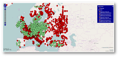
The substations are represented in the SciGRID model as the vertices of the transmission network. Two additional layers representing both abstracted and missing vertices in SciGRID are included on the map. Missing vertices (or substations) are vertices which exist in OSM database but are not members of any power relation, and therefore are missing from the SciGRID dataset.
The map includes abstracted and missing substations from SciGRID with their status on the 1st June 2015, which is the date of the first release of the SciGRID model and first dataset (available here). The map also includes abstracted and missing substations for the 09.11.2015 status. We intend to update the map data every month to account for the relations coverage progress in the OSM database.
The map is a contribution, which is intended to make the task of mappers easier. Mappers wanting to update the OSM power data in general and OSM power relations data in particular can directly use the map and access the substations via their ID which is linked to the OSM webpage.